Managing Agency: Tahoe National Forest
 Some may wonder why the Mears Meadow Trail was included in the guide.
With the areas of timber harvest that it passes through, I would not consider it one of the more scenic hikes.
And the destination, Mears Meadow, is surrounded by timber harvests and their debris.
Part of the reason it is included is that it is a Tahoe National Forest system trail and it is located in the North Fork watershed.
Another part of the reason it is included is to show what can happen to public trails; access problems, damage from timber management and loss of trails.
Some of this is due to the checkerboard of private properties that are within the boundaries of the forest.
Most of these scattered independently managed private properties are the remnants of the railroad grants from the construction of the Central Pacific Railroad.
This can often lead to trail closures and damage to public trails that cross these private lands.
Some may wonder why the Mears Meadow Trail was included in the guide.
With the areas of timber harvest that it passes through, I would not consider it one of the more scenic hikes.
And the destination, Mears Meadow, is surrounded by timber harvests and their debris.
Part of the reason it is included is that it is a Tahoe National Forest system trail and it is located in the North Fork watershed.
Another part of the reason it is included is to show what can happen to public trails; access problems, damage from timber management and loss of trails.
Some of this is due to the checkerboard of private properties that are within the boundaries of the forest.
Most of these scattered independently managed private properties are the remnants of the railroad grants from the construction of the Central Pacific Railroad.
This can often lead to trail closures and damage to public trails that cross these private lands.
The Mears Meadow Trail also provided a connection to the Big Valley and Monumental Creek trails, both of which have been damaged by timber harvests on private property. The Big Valley Trail has been pretty much completely erased. The Monumental Creek Trail has had roads built on top of it and been damaged by timber harvests in some areas. It was somewhat ironic to see an old trail sign on the Mears Meadow Trail for both of these trails. The sign had pointers to Monumental Creek, Big Valley, Lake Valley Reservoir and Mears Meadow.
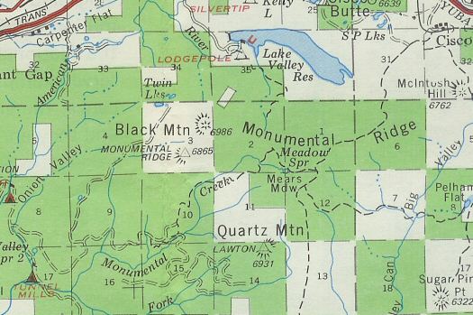 This 1974 Tahoe National Forest map, in addition to showing the private/public ownership, shows the Mears Meadow, Monumental Creek and Big Valley trails.
Bits and pieces of the Monumental Creek Trail can still be found and followed. It makes for an adventure and the forest down in Monumental Creek is nice. I have followed the upper 2 miles of the trail and parts of the likely alignment of the trail down lower.
From the obscure junction with the Mears Meadow Trail look SW for a corridor through the trees. There are no signs of the trail on the ground, but follow the corridor SW crossing a shallow drainage. Then head S a short distance to intersect a logging road. Follow this road to the right to where it crosses a saddle and then on down to the first switchback in the road. Go straight off the switchback and you should be able to find a trail that continues heading west. In a short distance the trail is at the top of a timber harvest area. Here the trail becomes hard to follow as the ground has been disturbed by the harvest operation. Around the first tractor path that comes up the slope head down. There are still some trees left on the slope that have the "i" blaze, but you may just want to pick your way down the slope using the tractor paths. Head down the slope and to the west staying on the south side of the creek. When you cross into section 10 the timber harvest stops, vegetation gets thick and you can start looking for signs of the trail again. It was a little hard to pick up, but head down toward the creek and look for the trail crossing. On the other side of the creek the trail is easier to follow.
The lower end of the Monumental Creek Trail likely used the Bradley-Gardner Ditch down near Onion Valley. Take Forest Road 19 (Emigrant Gap Rd / Texas Hill Rd) from Emigrant Gap to Onion Valley. Turn left onto FR 45, go a short distance and take the road to the right. Go a short distance and turn right onto FR 45-2. This road goes a little ways then drops down onto the ditch and continues on the ditch. The road/ditch gets more overgrown the further you go, so park where you feel comfortable. You can continue to hike on the ditch/road following the line of the ditch through brush and eventually to where it crosses Monumental Creek. I have not been able to determine where the trail from above intersected the ditch.
Another good hike is to continue to follow the Bradley-Gardner Ditch to its take on the East Fork of the North Fork of the North Fork. There are some fabulous rock walls along this section of the ditch as well as a nice view of the monuments in Monumental Creek.