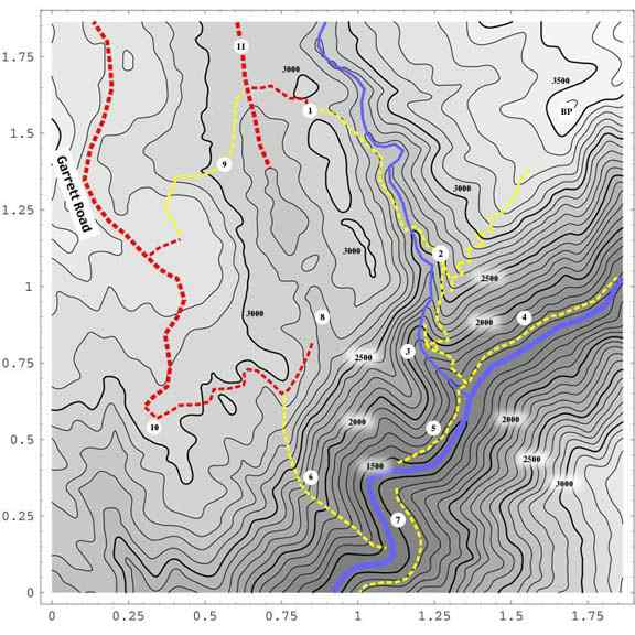
The map above depicts some of the roads and trails near Canyon Creek, the southern reaches of the Gold Run Diggings, and nearby portions of the North Fork American river and canyon. Contours are at 100-foot intervals with bold contours every 500 feet; the numbers along the bottom and left are in miles. The numbered locations are as follows:
1. Head of the Canyon Creek Trail at Potato Ravine Pass.
2. Waterfall View, where the trail to the Blasted Digger Overlook and Bogus Point forks off. Gorge Point is another quarter-mile down the trail to the south. Bogus Point itself is labeled "BP."
3. The Terraces, with the trail to the Big Waterfall.
4. The High Old Trail upriver.
5. The High Old Trail downriver, reaching Indiana Ravine, across from Pickering Bar.
6. Pickering Bar Trail.
7. Pickering Bar, and the old trail coming upriver from Ford's Bar.
8. The Secret World; a hydraulic mining pit; site of the Mill Claim, and terminus of the Indiana Hill Ditch. This is where gold was discovered in the Eocene gravels, in the spring of 1852. I sometimes call it the Indiana Hill Pit, but that name causes confusion, since the Big Pit of the Gold Run Ditch & Mining Company, to the north, is partly embraced by the actual Indiana Hill Claim.
9. The Paleobotanist Trail, from The Bluffs near Garrett Road, across the diggings to the Main Diggings Road.
10. Approximate location of the BLM gate at the end of Garrett Road. The road continues down to the head of the Pickering Bar Trail and to the Secret World.
11. The Main Diggings Road. This road goes
all the way north and east to the Dutch Flat exit on I-80, and
has access roads coming in from the Gold Run exit, and from the
eastern Gold Run exit area, as well.
Back to the North Fork Trails page.