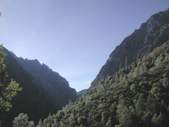
The deeply-gouged canyon of the North Fork American exposes a cross-section, as it were, of the complex of metamorphic rocks which dominate the bedrock series of rocks in this part of the Sierra. On the flanking ridges are remnants of the auriferous Eocene river gravels, and more continuous layers of the rhyolite volcanic ash and andesitic mudflow. Along the river itself are found, here and there, remarkable accumulations of Ica Age gravels, so deep as to have been hydraulically mined for their gold content. The various rock formations of the North Fork will be examined in the Geology section.
The unusual depth of this Slate Yosemite, and the character of surrounding landforms, such as the volcanic plateau of the Foresthill Divide, or the many tributary canyons which fed glaciers derived from South Yuba River basin ice, into the North Fork basin, will be examined in the Geomorphology section.
The geology of the North Fork American more or less exemplifies
the regional pattern, so from the beginning we must address local
geology within the context of Sierran geology. Of course, the
broader contexts are those of Californian geology, North American
geology, the geology of the Earth, planetary geology, and finally,
galactic and pan-galactic cosmology. Of these last it should be
remarked that the most abundant chemical element in the universe
is also the simplest: hydrogen. Further, the light and other forms
of energy emitted by stars is largely derived from the fusion
of hydrogen atoms into helium. The process does not stop there,
for within the hearts of stars, under tremendous pressure and
heat, helium in turn is transformed into still heavier and more
complex elements. Among these are silicon and iron and oxygen
and carbon; and even gold. Our sun and solar system may be second-generation
stellar objects, formed from the detritus of older stars. At any
rate, there is a larger fraction of heavier elements in our sun
and solar system, than theory would expect from a star of the
first generation. Hydrogen remains dominant in mass; the planets
are somewhat puny compared to the sun. The inner planets
are called the rocky planets, and all of them likely have iron-rich
cores. The Earth in particular is the largest of the rocky planets,
and has an outer core of molten iron and nickel, and an inner
core of solid iron and nickel.
Surrounding the core is the mantle, iron-rich silicates extending outward to the crust. The mantle comprises the larger part of the Earth's volume. Small amounts of radioactive heavy metals are dispersed throughout the dark rock of the mantle, and the constant decay of isotopes releases heat. This heat rises towards the surface in a process of convection; there are plumes of warmer, rising, lighter rocks, and sheets of downward-plunging, heavier, colder rocks. This slow overturn of mantle rocks is what drives continental drift and all volcanic activity. Throughout most of the mantle, pressures are too great for rock to assume a liquid (molten) form; but at a certain depth, around 100 miles below the surface, is a region called the asthenosphere, where pressures abate enough for the warmer fractions of mantle rock to melt into magma.
Now, the Earth is around 4.5 billion years old or so, and no direct record of its first billion years remains to us. We know, from the Moon (also about 4.5 billion years old), that a long period of heavy bombardment by meteors occurred in the first billion years or so. The Earth very likely attracted even more meteorites than did the Moon, and was even more thoroughly scarred and marked by craters than the Moon. What became of those craters? They have vanished entirely, because, unlike the Moon, the Earth has enough radiogenic elements in its mantle to generate sufficient heat to drive convective overturn of the mantle rocks. This overturn drags the colder, more rigid crustal rocks hither and thither. This is the mechanism of what is called continental drift; for the crust of the Earth is divided into a number of separate plates, and the continents, being formed from the lightest, most iron-poor and quartz-rich fraction of terrestrial minerals, float passively upon these moving plates. The Moon lacks the volume sufficient to generate enough heat for convective overturn and continental drift. It also lacks an atmosphere; so the record of bombardment is largely intact on the Moon, while the animate, creepy-crawly Earth, with its constant mountain-building and erosion, has lost the imprimatur of its ancient bombardment.
Typically, the molten rocks of the asthenosphere well up into the crust along linear structures called spreading zones. Most of these are found beneath the oceans of the world, and ridges of brand new volcanic rock mark their courses. One such is the Mid-Atlantic Ridge, which lies beneath the center of the Atlantic Ocean. Rock along the spreading zone is essentially brand new, while, as one takes samples farther and farther from the spreading zone, the rock of the oceanic crust gets older and older. Broadly speaking, this oceanic crust is an iron-rich volcanic rock called basalt. One might even regard it as the exposed surface of the mantle itself. On both sides of the Atlantic, near the continental margins of North American, Europe, South America, and Africaóand thus farthest from the spreading zone at the Mid-Atlantic Ridgeóthe ocean-floor basalt is found to be about 200 million years old.
The spreading zones are places where brand new crust is being formed constantly, and then spreads away to either side, as though on a conveyor belt. Meanwhile, there are also subduction zones, where cooled crustal rocks plunge back into the mantle, completing the convective overturn. Here again, volcanism results; the ìRing of Fireî girdling the great Pacific Ocean is almost entirely due to volcanism associated with subduction zones. It may happen that oceanic crust plunges beneath a continental margin, as it does along the west coast of South America, or near the states of Oregon and Washington; in such a case, a linear range of volcanos arises a little ways inland from the coast, as in the Andes or the Cascades.
We cannot pause here to examine the theory of continental drift in detail. The story of how the theory itself evolved is fascinating. For instance, from the time when the very first moderately accurate maps were made showing the coasts of South America and Africa, it has been observed that the two continents match up like pieces of a jigsaw puzzle. I myself pointed this out to my 4th-grade teacher, asking if the two continents had ever been attached. She replied, very sensibly for 1957, that although it appeared they had once fitted together, geologists knew that this could not have been. Speculation began on this fitting-together of Africa and South American at least as early as Sir Francis Bacon. The possibility was revived from time to time over the centuries, until in 1915 Alfred Wegener, a German meteorologist, positively asserted that the two continents had indeed once been joined, and roughed out the theory of continental drift. The theory held some sway in South America and Africa, but was more or less spurned by American and European geologists. Now, the ocean covers about 75% of the Earth, and this hidden surface is not at all easy to study directly. Consequently, the science of geology evolved under a heavy bias; we could see and touch the rocks of the continents, but, aside from knowing that the ocean is floored largely by basalt, until the 1960s we had but a poor idea of ocean floor geology. As the data came in from ocean-floor research during the 1957 Geophysical Year, and from ocean-floor drilling programs, during the 1960s, the continental drift theory became more and more plausible. By 1970, little or no serious opposition to the theory remained.
The USGS hosts a nice online introduction to continental drift. A closer look at Alfred Wegener is found here.
Here, however, we must set aside further development of the theory of continental drift (or ìplate tectonicsî), except to note that the basaltic ocean floor is itself often masked beneath accumulations of sediments. These tend to be deepest near continents, and also near the continents themselves are the coarsest sediments, sands and even pebbles. As one proceeds farther into the great deeps and abyssal plains of the open ocean, the sediments become thinner and finer, often consisting of clays. It may happen that a volcanic island is ringed by a coral reef; now imagine that the island, its reef, and the surrounding abyssal plain with its beds of fine sediments, are all alike drifting towards a subduction zone at a continental margin. As the oceanic plate plunges beneath the continental margin, portions of the basaltic crust, of the fine-grained sediments blanketing it, of the volcanic island, and even of the coral reef, may get scraped off and welded to the continent itself. Other portions may get fully subducted and melted into magma, to be reborn again as it were, as continental volcanos, or, supposing the magma never reaches the surface, it may cool into granite or some other type of intrusive igneous rock.
This scraping-off of material upon a continental margin is called ìcontinental accretionî and is one of the principal mechanisms by which continents grow. Not only are sediments of many kinds scraped off and attached, but portions of the sea-floor basalt, coral reefs and other limy biosediments, submarine lave flows, and the varied volcanic rocks which can make up a volcano, are all potentially involved. In theory this occurs deep beneath the surface, under tremendous pressure and strong shearing conditions. It is thought to often be associated with the formation of magma which may or may not reach the surface. Finally, continental accretion, at an active oceanic-crust subduction zone along the margin of a continent, may continue over a period many millions of years and add long, somewhat linear bands of more or less metamorphosed rock to the continent.
This seems to have been the case with California and in particular, the Sierra Nevada. Geologists call the linear bands of rock ìterranesî and struggle mightily to develop plausible models for the accretion of these terranes in California and the Sierra Nevada. The Sierra, like most major crustal structures in California, trends northwest-southeast. Currently it resembles one long ridge, extending 400 miles from near the southern terminus of the Cascade volcanoes at Mt. Lassen, southeast, to where it finally dwindles and merges with the Transverse Range, in the Kern River country south and east of Bakersfield. This monstrous ridge, sometimes called the longest single mountain range in North America, has a long, gently sloping western slope, and a short, steep eastern slope, both slopes riven by deep canyons. Under the prevalent model of Sierran geologic history, this long range has been uplifted like a huge trap door, the ìhingesî near the eastern edge of the Great Central Valley. It has not been lifted evenly: only around 5,000 feet in the north, but over 10,000 feet in the south. All along the eastern side of the Sierra are fresh and still-active faults, along which the Sierra has broken free from rocks to the east. Somewhere, beneath the deep and mostly unconsolidated sediments of the Central Valley, is hidden the presumed faulted contact between Sierran rocks and those of the Coast Ranges.

Broadly speaking we may divide the west slope of the Sierra into uplands and canyons. The canyons are fresh and young and steep and rocky. The uplands are often gently rolling areas with much deeper soils than within the canyons, and consequently, much more vegetation. Rocks are well-exposed within the canyons, but often masked by soils and vegetation in the uplands between the canyons. In the higher elevations, above the 5-6,000 foot level, the Sierra has been severely glaciated, and rocks are often well-exposed everywhere, in canyons and uplands alike. All this is only to say that we can easily observe and study Sierran rocks; the long linear bands of metavolcanic and metasedimentary rocks, trending parallel to the Sierra crest and at right angles to the major canyons, are well exposed. The metamorphics are much more prevalent in the northern part of the Sierra; to the south, granite predominates, a sparkling porridge of crystals with its light-colored quartz and feldspar. This granite is actually made up of hundreds of distinct masses called plutons, each with a unique mineralogy and age. Most of the granite is from the Triassic, Jurassic and Cretaceous and seems to have been a product of that same subduction which added the linear terranes of metamorphic rock to the continental margin. The granite magmas, according to the usual ideas, rose into the metamorphic rocks from below, consuming vast volumes of said metamorphic rocks and assimilating them into the melt in the process. Thus the granite entered from below as hundreds of pluton-bubbles of magma, and the metamorphic rocks are thought to remain as ìroof pendantsî perched upon a generalized batholith of granite at depth. The southern Sierra Nevada is not only higher now, but seems to have been subjected to more uplift than in the north over a long period; this is thought to explain the relative scarcity of the metamorphic roof rocks in the south: they have simply been eroded away, and the granite batholith, unroofed.
Generally, then, the Northern Sierra is composed of metamorphic rock, here and there intruded by granitoid plutons, while the Southern Sierra is composed by granitoid rocks, here and there punctuated by metamorphic rocks. The North Fork American is entrenched, almost entirely, into metamorphic rocks. This may be the key to its unusual depth, as will be discussed below in the Geomorphology section. The metamorphic rocks are of many types: slate, greenstone, meta-limestone, meta-sandstone, meta-conglomerate, serpentine, chert, meta-volcanic ash, meta-volcanic mudflow, and meta-igneous intrusive rocks. The entire metamorphic complex has been tilted up into a near-vertical orientation, or even slightly overturned to the east. It is laced through and through with ancient faults, mostly trending parallel to the linear terranes, often forming terrane boundaries. The task of sorting out the ages and provenances of these metamorphic terranes is difficult. There is little in the way of macro-fossils to help pin down dates, for the rocks were mainly metamorphosed from deep-ocean sedimentary and volcanic materials which are notoriously poor in fossils. Still, there are ammonites scattered widely, and within the limestone, crinoids and bryozoan fossils are sometimes found. The chert contains fossil radiolaria. Often, the heat and pressure which metamorphosed these rocks also served to destroy or distort the fossils.
From the days of Josiah Whitney and his California Geological Survey of the 1860s, it has been recognized that these Sierran metamorphic rocks are Paleozoic and Mesozoic in age. They are intruded by granites (or rather, granitoid rocks often approximating granodiorite in composition) of Triassic, Jurassic, and Cretaceous ages. The turned-up-on-edge slates and other metamorphic rocks are conspicuous throughout much of the foothill region, where the 49ers focused their attention, and Whitney recognized the profound unconformity between these up-turned slates and the younger, flat-lying sediments of the Great Central Valley which lap over the older rocks in places.
In later years, the main act of metamorphism, along with the system of faults threading the metamorphic complex, and the over-turning of the rocks, came to be called the Nevadan Orogeny (or "mountain-building"). This orogeny is dated to about 150 million years b.p. (before the present). Some geologists discern older orogenies in the Sierran metamorphic complex. Most of the granites were emplaced after the Nevadan Orogeny, for quite typically the granite plutons span terrane boundaries and the old faults (if the granites had been cut by the faults, then the faults would be younger than the granites). It has been speculated that emplacement of Sierran granite occurred as a result of ocean-fllor subduction and remelting, with the associated accreted rocks comprising the Franciscan Formation, widely exposed in Californiaís Coast Ranges.
One of the salient facts about these metamorphic rocks and the granitoid intrusives, is that they have been exhumed from great depths. The rocks we see on the surface today were once miles underground. Long-continued uplift and erosion has gradually exposed these rocks. While buried and undergoing metamorphism, the heat and pressure rendered them ductile, and there was much in the way of folding into sharp synclines and anticlines. Subsequently, the cooling of the granite pluton-bubbles led to the infusion of surrounding rocks with quartz-rich fluids, often carrying trace amounts of various metals. These fluids found their way into every convenient fracture, joint, and fault zone, forming the quartz veins from which so many millions of ounces of gold have been recovered.
Since the rocks exposed today are known to have been deeply buried, it follows that they have been uplifted and deeply eroded. Little is known about the ancestral Sierra, which must have reared high above the ocean waters lapping at its base, where the Central Valley is now. The picture begins to come into focus around 55 million years ago, in Eocene times. By then the miles of rock had been stripped away, and the Sierra was reduced to an Appalachian-like system of parallel ridges dividing sluggish, meandering rivers, under a wet subtropical climate. The long cycle of erosion had exposed the granites and the quartz veins they had spawned, releasing the gold into the sluggish rivers. The warm, summer-wet climate was just the ticket to rot the rocks to great depths, and in places around the Sierra foothills, patches of ancient, deep, red soils survive to this day, artifacts of the Eocene.
Around 30 m.y.b.p., a long sequence of volcanism commenced which profoundly affected the ancestral Sierra. In the Miocene, rhyolite ash was erupted in great cataclysms from points east of today's crest. Since the Sierra was worn down low and humble, the erupted volumes of incandescent ash were able to spread westward easily. As soon as the glowing avalanches stopped moving, they froze into welded tuffs. These are found today at the higher elevations, as much as ten miles or more west of the crest. However, these welded tuffs make up but a fraction of the entire volume of rhyolite ash; it sifted down from the sky over the entire region, and was laid down in such quantities as to fill some of the Eocene-age valleys to the brim. These layers of ash accumulated to depths of as much as 400 feet or more, and were immediately attacked by rains and rivers and redistributed even farther to the west and downslope. The type of the rhylolite ash series is called the Valley Springs formation. When visible, it resembles layers of white, grey, or tan sandstone or clay.
The rhyolitic eruptions continued for around ten million years, and then a more mafic, iron-rich sequence of volcanic activty commenced. Great strato-volcanos must have formed, around the present crest, and a long series of andesitic mudflows (lahars) issued forth. What the rhyolitic eruptions had begun, the andesitic eruptions finished. Except for a few of the highest ridges, made of the most resistant of all the old metamorphic rocks, the ridges and valleys of the ancestral Sierra were buried wholesale. A vast volcanic plateau covered all of the upper and middle elevations, and extended well down into the foothills in many places. Again, these lahars were depositied over millions of years, from about 10 m.y.b.p. to about 3 m.y.b.p. The type of the andesitic mudflow series is called the Mehrten formation. These mudflows are often exposed to view, looking for all the world like massive beds of rough gray cement, with embedded cobbles and boulders of andesite, in a matrix of gray andesitic ash.
Over the entire period of volcanism, the disruption of the Eocene drainage pattern gave rise to new river courses (or ìinter-volcanicî channels), carving new valleys, some more or less persistent, others quickly buried under new deluges of volcanic debris. In places these new river channels carved deeply enough to rob volumes of gravel and clay and sand from the older, pre-volcanic Eocene channels.
Near the close of the great volcanic sequence, basaltic lavas erupted and flowed down the inter-volcanic channels. These basalts are the very youngest of the Mio-Pliocene volcanic rocks, and near the North Fork American they are found near the Sierra crest, for the most part. The most notable exposure is at Devils Peak, where the basalt has a fairly well-developed columnar structure. These basalts have been dated to about 3 to 6 m.y.b.p.
At this point in our story, the most important concept is that an older, Eocene landscape had been buried beneath younger, Miocene and Pliocene, volcanic rocks. Subsequently, under the traditional model of the evolution of the Sierran landscape, the range was uplifted and tilted to the southwest, imparting a brand new and steeper gradient to the generalized volcanic plateau. Most of the rivers of the northern and central Sierra are considered to be ìconsequentî to this uplift; they are artifacts of the regional tilt to the southwest, incising new canyons into the uplifted plateau. In the meantime, profound climatic changes were occurring; the Ice Ages, marking the base of the Pleistocene, and once though to have begun around 1 m.y.b.p., are now considered to have started, in the Sierra, around 3 m.y.b.p., based upon the dating of lavas overlying glacial tills, near Mammoth.
A long series of distinct glacial advances and retreats began, with the glaciers themselves by and large confined to the middle and upper elevations. The new canyons rapidly deepened, cutting easily through the soft and weakly consolidated volcanics into the bedrock below. With an abundance of meltwater from the glaciers, along with masses of sand and gravel and boulders, the rivers performed miracles of erosion, and gave us the deep canyons we delight in today. In many places these new canyons cut the courses of the Eocene valleys and robbed the ancient gravels. The new canyons deepened well below the old Eocene land surface, the disparity being greatest in the middle elevations, where today's rivers flow 2000 feet below the level of the Eocene valleys.
The last several of a long series of glacial advances and retreats occurred within the past 100,000 years. These glacial maxima are named the
1. Tioga. 10,000 to 22,500 b.p.
2. Tenaya. 27,000 to 37,000 b.p.
3. Tahoe. 65,000 to 75,000 b.p.
Some of the older glacial maxima are termed the Tahoe 1, 130,000 to 160,000 b.p.; the Sherwin, about 760,000 b.p.; and the McGee stage, about 1.5 million years b.p. The moraine deposits left by Sierran glaciers are best preserved on the east side of the range, where there is much less in the way of rainfall. There, huge moraines extend out into the desert from the eastside canyons. On the western, seaward slope of the Sierra, abundant rain and snow and forest cover conspire to melt moraines away or hide them from view. It is fair to say that the glacial record is far more difficult to discover and interpret on the western slopes of the Sierra. However, quite a number of moraines may be found in the upper basin of the North Fork American, along with glacial striae (scratches made on bedrock surfaces by rocks embedded in the flowing glacier) and glacial erratics (boulders left behind when the ice melted, transported from some distance away).
So far as the glacial history of the North Fork American, it is significant that the North Fork canyon is much deeper than that of the South Yuba to the north. During glacial maxima a kind of generalized ice cap covered the higher elevations, leaving various peaks projecting above the ice. It seems that the granitoid rocks which floor much of the upper South Yuba basin are much more resistant to glacial erosion, and perhaps also more resistant to processes of mass wasting and fluvial erosion, than the slates and metamorphosed sediments and volcanics of the North Fork American. The upper South Yuba is a rather broad and shallow valley. Once it filled with ice, any additional ice would spill to the south into the North Fork American. Among the northern tributaries of the North Fork American which conducted South Yuba ice into the great canyon we may list Serena Creek, Palisade Creek, Big Granite Creek, Little Granite Creek, Big Valley Creek, the East Fork of the North Fork of the North Fork American, the North Fork of the North Fork American, Fulda Creek, and Blue Canyon. It is even possible that some South Yuba ice found its way into the head of Canyon Creek, near the Drum Forebay exit on I-80.
Moraine deposits and glacial erratics of the youngest, ìTiogaî stage of glaciation are the commonest, and where granitoid boulders are present, the boulders are fresh, and do not have a deeply weathered, reddened, crumbly surface rind. Older moraine deposits do exhibit such deeply weathered boulders. Over the past several years, Professor Allan James, of the University of South Carolina, has used cosmogenic dating to establish the ages of moraines in the upper Bear and South Yuba watersheds. Cosmogenic dating relies upon isotopic changes to various elements bound within minerals in rocks, say, to the element beryllium. When a boulder is fully exposed to the sky, say, atop a moraine, or if an erratic perched high on a sunny dome of rock, it is constantly bombarded by cosmic rays. These penetrate well into the rock and cause isotopic changes to various elements. Knowing, then, what ratios between two measurable isotopes exist in a rock's native state (before exposure to cosmic rays), one can compare the ratios measured in a boulder exposed to cosmic rays, and calculate the length of time it has been exposed.
The valley glacier which flowed down the North Fork during the most recent, Tioga stage, seems to have reached down to Mumford Bar, or a little beyond. Older, more intense glaciations seem to have pushed the terminus down to Humbug Canyon; it is not beyond the bounds of possibility that the valley glacier reached Giant Gap itself in the distant past. In the 19th century, it was often assumed that the North Fork glacier had reached Giant Gap, but there is nothing in the way of glacial striae or erratics to support this notion. However, there are very significant and curious deposits of Quaternary, Ice Age "glacial outwash" gravels in Green Valley, and related deposits forming some of the larger, higher gravel bars up- and downstream, such as Humbug Bar, Euchre Bar, Pickering Bar and Fords Bar.
I theorize that during glacial maxima, the bed load of sediment of the North Fork was greatly increased, and exceeded the carrying capacity of the river. These glacial outwash sediments built up into a more or less narrow floodplain extending for miles down the canyon. Then, during interglacial periods, the bed load was reduced below the carrying capacity of the river, and it would quickly begin ripping out the more or less narrow floodplain and cutting back down to its native bedrock channel, such as we see today. Here and there remants of the narrow floodplain persist, as at the above-named gravel bars.
Giant Gap from a knoll (The Pyramid)
in the west end of Green Valley; Lovers Leap on the right.
The most exceptional accumulation of these Quaternary gravels is in Green Valley, where serpentine of the Melones Fault Zone is cut by the canyon. The weak serpentine eroded much more quickly than rocks flanking it to the east or, especially, to the west. There a very resistant belt of Paleozoic greenstone caused the canyon to form a narrow gorge, bounded by tremendous cliffs. This gorge is called Giant Gap, and one of the cliffs is known as Lovers Leap. At Lovers Leap the canyon is about 2500 feet deep and 5000 feet across, rim to rim, giving an average slope angle of 45 degrees. This is exceptionally steep. Immediately upstream the canyon widens to three and near four miles across, in the weak, sheared and shattered serpentines of the Melones Fault Zone. Not only is the canyon wider here, but the gradient (slope) of the river is less than it is either upstream or downstream. This seems to have facilitated the deposition of the Quaternary gravels. To me it seems incredible, but these gravels may be found 400 to 500 feet above the river! They are so deep, and so great in volume, as to have been mined by the hydraulic method in the 19th century.
Green Valley also sports several bedrock knolls of suspicious, oh, very suspicious! appearance. To me they evoke the idea of the river meandering over a broad floodplain, the knolls marking the (transient) positions of particular meanders. It is possible that cosmogenic dating of the rock surfaces of these knoll, and of the cliffs in and around Giant Gap, will help to unravel and explain the mystery of the deep Quaternary gravels of Green Valley. For many years I have hoped that some ambitious professor of geology, with an interest in Sierran glacial history, sedimentology, and geomorphology, would sieze upon Green Valley as the project of a lifetime, and lead veritable hordes of graduate students there, over decades of time, and once and for all discover the geologic historic of Green Valley. The goal must include the correlation of particular strata of gravel in Green Valley, with particular glacial stages in the upper North Fork.
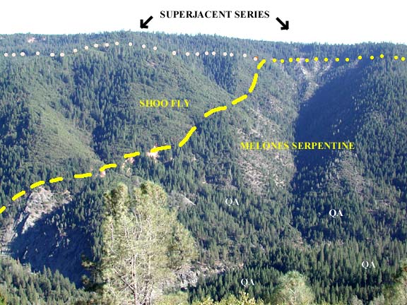
We have touched upon the principal rock units near the North Fork American. The presence, in the uplands flanking the canyons, of the nearly flat-lying strata of Eocene river gravels, (Valley Springs) Miocene rhyolite ash, and (Mehrten) Pliocene andesitic mudflows, resting unconformably upon the much older and steeply-dipping metamorphic rocks exposed in the canyons themselves, prompted early geologists to adopt a rough and ready division of all these various rocks into what were called the Superjacent Series (lying above), and the Subjacent Series (lying below) or colloquially, the bedrock. The student of Sierran geology must and will soon become able to distinguish these two broad types at a glance. Especially in the Northern Sierra and, in particular, near the North Fork American in the middle elevations, the ridges dividing canyons have flat tops. These flat tops are remnants of the generalized andesitic mudflow plateau. Typically these ridges have a heavy forest cover, and on the tip top of the flat surface, only a few scattered boulders of andesite may exist to reveal the mudflow. Below the mudflow lies the rhyolite ash layers of the Valley Springs formation. These light-colored, white to grey to buff beds of volcanic ash are often entirely hidden, exposed only in roadcuts. In fact, the andesitic boulders which constantly weather free from the mudflow matrix above, often roll downslope onto the hidden rhyolite ash layer, further confusing the issue. Only very occasionally are there any natural outcrops of this rhyolite ash; for instance, near Lake Alta, or at Chalk Bluffs, near You Bet, or near the head of the Green Valley Trail on the north side of the canyon.
When on either rim of the North Fork canyon, looking across to the far canyon wall one can usually easily see the contact between the volcanics of the Superjacent Series and the metamorphic rocks of the Subjacent Series. The contact is often two or three hundred feet below the more or less flat-topped ridge crests; it is the pre-volcanic land surface, seen in cross section. With a careful examination of this contact one can often discern the contact sloping to the east or the west, revealing the existence of pre-volcanic valleys and ridges. For instance, from the south rim of the canyon above Green Valley, looking north, one can see the contact quite easily; the volcanics actually pinch out to nothing in the vicinity of Lovers Leap (at 4139 feet), showing that it was an ancestral, pre-volcanic ridge which stood high enough to escape burial under the mudflows, and to the east the contact drops steadily into what is called the Nary Red channel (at 3600 feet), an Eocene and intervolcanic-age river which flowed north to join the Eocene Dutch Flat channel.
I want to emphasize that even the beginner in geology can easily learn to distinguish the young volcanics and river gravels of the Superjacent Series, from the older metamorphics and granites of the Subjacent Series. The 49ers themselves rather quickly learned the distinction and this business of tracing the contacts along the upper walls of the canyons was taken very seriously. In this way one could discover the auriferous (gold-bearing) gravels of the ancient, Eocene, pre-volcanic rivers. During the 1850s an intense effort was mounted to establish the precise courses of these ancient rivers. These Eocene gravels (ca. 55 m.y.b.p.) are often as much as 400 feet thick. The fine gold they contain is broadly disseminated through the gravels, and could only be worked profitably by the hydraulic mining method, except that, in the deepest part of the ancient channels, in the five or ten feet of gravel above bedrock, enough in the way of coarse gold could be found to justify drift mining. There are literally hundreds of old mine tunnels near the North Fork American, driven laterally into the ridges in hopes of striking the bed of an ancient river, or in some cases, merely following the bed of such a river directly in from where it is exposed on the canyon wall.
The tropical, wet and warm, rock-rotting climate of the Eocene Sierra tended to reduce many pebbles and even boulders, buried in the floodplains of the meandering rivers, to clay. Only the most resistant rocks escaped this dissolution, and these were mostly white quartz and chert (a quartz-rich rock) of various colors. If one is out hiking near the Subjacent-Superjacent contact and sees lots of rounded white quartz pebbles, it is certain that one of the Eocene channls is close by. These white pebbles are considered a special signature of the Eocene gravels. The most significant exposure of Eocene gravels near the North Fork American is from what is known as the Ancestral South Yuba channel, at Iowa Hill and Gold Run. Other channels are found near Alta (the Nary Red channel), and farther east at Blue Bluffs and Lost Camp, and around the head of Humbug Canyon. The Eocene channels are in fact ubitquitous, and can be found in many places along the North Fork canyon, high above the river.
Perhaps the most difficult part of the local geology is the bedrock, or Subjacent Series. We have already touched upon how the metamorphic rocks were accreted onto the continental margin in long linear strips, striking roughly parallel to the Sierra crest. To say exactly where these rocks came from, exactly when they were accreted, exactly how they were tilted up into their present steeply-dipping beds, or even exactly how old all these disparate rocks are, is more or less beyond our current understanding. Although considerable field work has been done, and considerable laboratory work, by many people, over a long period of time, still much disagreement and uncertainty remains. It cannot be within the scope of this essay to examine these rocks in detail.
Still, a few of the most salient features can be set forth. Even in the 1870s, geologists had learned to separate the obviously complex metamorphic rock bands into three broad groups, sometimes called the Lower, Middle, and Upper Slate(s), according to how far the rocks stood from the Central Valley. For instance, the serpentine of the Melones Fault Zone was considered to divide the Middle Slate and Upper Slate. This long body of serpentine crosses the North Fork American at Green Valley, in faulted contact with the metavolcanic greenstone of the Calaveras Complex on the west, and with the metasedimentary slates and limestones and associated rocks of the Shoo Fly Complex on the east. It was remarked above that the contact between the younger volcanics of the Superjacent Series and the serpentine of the Subjacent Series is easily discerned, near the canyon rim above Green Valley. Now, serpentine is a mildly poisonous rock, as it were, and soils developed upon this substrate diminish plantsí ability to take up water. It is somewhat as though a drought were imposed, and at Green Valley as elswhere, vegetational patterns change abruptly at the contact between the serpentine and other rock types.
Thus, the contacts between the Melones Fault Zone serpentine and the flanking rocks of the Calaveras Complex and Shoo Fly Complex are easily discerned. The ubitquitous Kelloggís Black Oak will not grow on serpentine, and Ponderosa pines usually give way to Digger pines.
East of the Feather River Peridotite (Melones serpentine) lies the Shoo Fly Complex. For miles, the North Fork American cuts rocks of the Shoo Fly. These are nearly entirely metasedimentary, and are the oldest rocks in the Sierra, being at least early Paleozoic in age, and are regarded as being derived from a continental source. The Shoo Fly begins at the east end of Green Valley, where a small lens of meta-limestone is in faulted contact with the serpentine, and continues for mile after mile up the canyon. In some places it its slate-like, but as Big Valley Bluff is approached (a 3500-foot cliff, and one of the most amazing viewpoints of the North Fork), the Shoo Fly is composed mainly of meta-sandstone, called graywacke. The uppermost unit of the Shoo Fly seems to be the chert exposed at Duncan Peak and Quartz Mountain, on opposite sides of the canyon near Big Valley Bluff. This light-colored, quartz-rich, fine-grained rock is called the Duncan Chert.
East of the Shoo Fly, and structurally above, lying unconformably upon it, are rocks of the Taylorsville sequence. These are exposed in Big Valley and at Sugar Pine Point. Next comes the Jurassic metasediments of the Sailor Canyon Formation, in which fossil ammonites can be found very locally, and then suddenly the metamorphics change to intrusive and extrusive volcanics of Jurassic age, much more massive and resistant to erosion than the rocks of the Taylorsville Sequence or the Sailor Canyon Formation. These massive rocks form the great bulk of Snow Mountain, whose summit, at slightly above 8000 feet in elevation, stands fully 4600 feet above the North Fork, at the confluence of Wildcat Canyon. This is quite astoundingly deep for a canyon anywhere in the world, and especially, for the Northern Sierra. Snow Mountain is comparable to Half Dome, in Yosemite Valley, which rises 4500 feet above the Merced River.
Finally, near the conflunce with Palisade Creek, east of Snow Mountain, the first granitoid rocks are reached. As will be discussed in the Geomorphology section, the granites of this area seem to ratherly stoutly resist glacial erosion. At any rate, the North Fork has not been able to lower its bed as drastically in these granites near Palisade Creek, and as a result, there is a very steep gradient on the river between Wabena Canyon and Palisade Creek. The entire river plunges over small cliffs in a series of beautiful waterfalls, in what is named the Royal Gorge of the North Fork of the American River.
We have seen the metamorphic sequence go from the Sailor Canyon Formation, through the Jurassic pyroclastics and Jurassic intrusives of Snow Mountain, to be briefly erased by the Cretaceous granites of Palisade Creek. Continuing upstream, we re-enter the Jurassic intrusives, then the Jurassic pyroclastics, then the Sailor Canyon Formation. That is, the sequence reappears in reverse order. This is what is called a "synclinorium." Where a syncline is a downward bend or fold in strata of rock, a synclinorium is a downward fold in a complex or system of disparate rocks. This seems to be the case here, moreover, this synclinorium is regarded as "the" synclinorium of the Sierra Nevada, identified as the locus for most granitic magmatism and thus the emplacement of the famous granite batholith of the Sierra (see Geology of the Sierra Nevada, Bulletin 190 of the California Division of Mines and Geology, by Paul Bateman and Clyde Wahrhaftig, 1966).
Passing farther up the canyon, more granites appear, and at Painted Rock, a last vestige of metamorphics is found, mapped once as part of the Taylorsville Sequence (thus, further extending the reverse-ordered repetition of rocks to the west, in the east limb of the synclinorium). At the very head of the canyon, the Sierra Crest and peaks of the uppermost Foresthill Divide have a thick volcanic cap, containing the usual Valley Springs rhyolite (but with a welded tuff unit included here), the andesitic lahars of the Mehrten Formation, and in many places, still-younger lavas apparently coeval with the basalt capping Devils Peak.
Such is a brief sketch of the geology of the
North Fork American, in its middle and upper reaches.
Why is land shaped the way it is? Why is a valley, a valley; a mountain, a mountain? The study of landforms, and erosive and sedimentary processes, falls roughly under the heading of geomorphology.
Some of the salient aspects of the geomorphology of the North Fork American have already been touched upon: the North Fork American, like all the forks of the Yuba and other rivers in the northern Sierra, presents the appearance of a deep canyon incised into gently-rolling uplands. We might almost tell a "Tale of Two Morphologies," for there is an ancestral, ancient Sierra Nevada hidden among the uplands between our modern canyons.
The essentials of the evolution of the local landscape are somewhat as follows: metamorphic and granitic rocks were uplifted and exposed to a long cycle of erosion, leaving what has been called an "Appalachian" landscape, in which the more resistant rocks stood as ridges, and the weaker rocks became the site of valleys. The entire system of ridges and valleys trended northwest-southeast, having been determined by the linear bands of rock accreted to the continental margin millions of years before.
In the Eocene, sluggish rivers meandered through this Appalachian landscape, under a tropical climatic regime which rotted rocks deeply. The valleys filled with sediments, and under the rock-rocking climate, of summer, monsoonal rains and warm weather year-around, many cobbles and boulders within the sediments rotted into clay and left only the most resistant cobbles and boulders, of quartz and chert, intact.
Subsequently, Micene eruptions of rhyolite ash, and Mio-Pliocene effusions of andesitic mudflow lahars, buried this ancestral landscape. A gently-sloping plateau of andesitic mudflow covered this entire area, from the Mokelumne (and beyond) on the south, to the Feather River on the north.
Back to North Fork American index page
Back to Russell Towle's homepage